
Could Indonesia Be Heading for Another 1998 Crisis? An Economist Explains
As a result, he believes that the prerequisites for a large-scale political transformation similar to 1998 have not yet emerged.
news
As a result, he believes that the prerequisites for a large-scale political transformation similar to 1998 have not yet emerged.
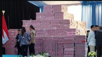
The handover ceremony took place at the headquarters of the Attorney Generals Office of Indonesia in Jakarta, where stacks of cash were displayed prominently in the main courtyard.

Meanwhile, Bank Indonesias Jakarta Interbank Spot Dollar Rate (Jisdor) set the rupiah at Rp17,375 per US dollar.

TheIndonesia.co - Indonesia is one of the world's greatest archipelago countries, with over 17 thousand islands. The map shows Indonesia straddles the equator between the South China Sea and the Pacific Ocean in the north and the Indian Ocean in the south.
Astronomically, Indonesia is located at 6 degrees north latitude and 11 degrees south latitude to 92 degrees east longitude and 141 degrees east longitude.
Visitors can reach Indonesia by land travel from Malaysia, Papua New Guinea, and Timor Leste. Check out the review of the following Indonesian territorial boundaries.
Land Border
Indonesia has a total land border of 3,108.3 kilometers (km). Indonesia's borders include the west, east, north, and south.
Malaysia
Indonesia shares land borders with Malaysia on the island of Kalimantan or known as Borneo. The provinces of East Kalimantan, North Kalimantan, and West Kalimantan are directly adjacent to Malaysia. Meanwhile, Malaysia's state of Sabah and Sarawak is directly next to Borneo Indonesia's northern part. The length of the border is 2,019.5 km.
Papua New Guinea
The length of the boundary between Indonesia and Papua New Guinea is 820 km. Papua Province is directly next to Papua New Guinea's provinces, Sandaun and West Papua.
Timor Leste
The border between Indonesia and Timor Leste is located on the island of Timor. The province of East Nusa Tenggara Indonesia is next to Bobonaro and Covalima, the special administrative area of Oecusse, Timor Leste. Timor Leste also has an exclave in Indonesia's East Nusa Tenggara province, named Oecusse.
The length of the border between Indonesia and Timor Leste is 268.8 km.
The maritime boundary is calculated from the country's baseline to 12 miles of the sea. The baseline is an imaginary line drawn from the seashore connecting various points on the island's tip. Here are the Indonesian maritime boundaries: